Headless Cross, Grimford Anderton
I drive every day along Bolton Road A673 (Chorley Old Road), and have always been intrigued by the triangular layout of the roads at Grimeford / Headless Cross / Millstone.
The A673 was turnpiked in 1765 and looks to sit over the pre-existing road network.
Additionally, we have the Headless Cross with 4 directions on it with only 3 roads leading away, and some stocks.
Search on the Internet for Headless Cross, Anderton, and you will discover quite a story. The cross was allegedly found when the nearby reservoir was built in 1850. The top section is now in the Harris Museum, Preston, the lower half is at the roadside. However, I was sure that I had seen the name Headless Cross" on maps from before the reservoir was built.
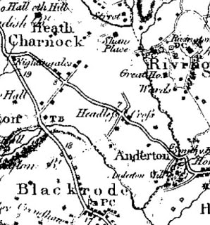
Yates - 1786
The earliest map I can find with Headless Cross marked on it is Yates of 1786. Headless Cross is clearly marked, and shown as a crossroad, whereas today there are only 3 roads.
The Adlington to Horwich road has been altered at least once as Rivington reservoir now covers some of the section between the Milstone and Anderton Ford.
The FactsFrequently mentioned are deeds printers in the Chartulary of Cockersand Abbey, circa 1184-1190:
‘Grant in frankalmoign from Ranulf Gogard and his heirs to God [and the canons of Cockersand] for the health of the souls of his mother and his wife Edith, of all the land from Fulford to the path which crosses Rascahay Brook, between Heath Charnock and Adlington, as it was marked out by the crosses and marks of the said canons; with comon right of Charnock, in wood and plain, feeding grounds and mast in all other liberties.'”
Randle Gogard gave to Cockersand Abbey, for the health of the souls of his mother and his wife Edith, the land between Fulford and the path over Rascahay Brook, as marked out by the canons' crosses; Cockersand Cbartul. (Chet. Soc.), ii, 510. Robert Gogard occurs in 1203;
Of interest here is the location of the land between Fulford and the path over Rascahay Brook between Heath Charnock and Adlington. The current boundary is Eller Brook. However, I am already investigating an un-named old boundary stream which separates Anderton, Adlington and Heath Charnock.
From "English Place-Name Elements Relating to Boudaries" we find:
Roscoe Low: (rivulum de) Rascahae 1184-90 CC, ?de Rascok, de Rachecok 1246 LAR (CC 2:1:510 f, rendering rivulum de Rascahaeby „Rascahay brook‟, Fellows-Jensen 1985:154: “The specific is the Scandappellative rá f. „roe-deer‟. The generic is the Scand appellative skógr m. „wood‟, with the first form showing onfusion with cognate OE sceaga m. „wood‟ (PNLa 128).”, PNLa 128: “Roscoe Low seems to go O.N. rā-skōgr meaning either “roe wood” or possibly “boundary wood.” Rascahae is apparently an anglicized form.”).
Roscoe Low is in the township of Anderton in the parish of Standish, and the fact that Anderton forms a projecting part of this parish, so that the greater part of the township boundary is also the parish boundary (see VHLa 6:182), may speak for rá „boundary‟ as the first part of Roscoe. Low (PNLa) or Law (Fellows-Jensen) is probably OE hlāw „hill‟. Roscoe Low is a 525 feet high hill, see PNLa loc.cit
Of course, Roscoe Low farm is only 100m from the Headless Cross and at the centre of Anderton. If we go 1 mile north to the boundary with Heath Charnock, we find the un-named boundary brook.
The Headless Cross. "There used to be a headless cross in Anderton but old Mr Ridgway of Ridgemont removed it many years ago" (a). (3)
SD 61901302 According to Mrs Coupe this feature was brought back from Ridgemont many years ago, and re-erected on or near its old site. The stone is cemented into a thin stone slab, now broken, and stands within an enclosure bounded by four small cylindrical pillars. No conclusions could be reached regarding the origin of this stone. The possibility cannot be excluded that the stone is the work of some fairly recent eccentric. In the churchyard at Rivington there are many stones, some with 17th century dates, and most bearing complex carvings and designs, and quite unlike any other stones of comparable period previously encountered in this region. According to Mrs Coupe these stones in the churchyard also came from Ridgemont suggesting that a former occupier may have manufactured these stones as 'objects of antiquity'. On the top of the sculptured stone is a flat slab which appears to be the table of a sundial. The stone is obviously not part of the feature to which it is now fixed, but its original place of origin could not be ascertained. It is considered that the authenticity of the whole of this feature is very suspect. The position given by Winstanley (2) applies to a spot height and is not that of the sculptured stone. (4)
( 5) Field Investigators Comments
F2 ISS 29-JAN-76
The so-called 'Headless Cross' is now re-erected on or near what is believed locally to be its original site at SD 61901302. It consists of an upright sculptured stone 0.6m by 0.3m and 1.0m high, with, on one side, the lower half of a human figure in relief, and on the other a crude lattice design. This is capped by a flat slab, which is an inscribed guidestone, with the seating for a sundial. As it stands, it is clearly not remains of the cross that the traditional name suggests stood here; nor is the lower stone part of a Roman altar. It seems more likely to be a composite sundial, but it is now impossible to say whether it is an original assemblage, or was constructed at its interim site. (5)
( 8) General reference
nglish Heritage Scheduling Amendment 9/8/94
SD 6189 1300. Headless Cross, Grimeford. Scheduled RSM No 23748. Part of the shaft of an Anglo-Saxon decorated cross measuring 1.05m high by 0.64m wide and 0.27m deep, on a modern base. It is decorated on all four faces. On the top of the shaft there is a post-medieval slat sandstone slab, originally thought to have been the table of a sundial, which has latterly been used as a direction stone by having the words TO PRESTON, TO WIGGAN, TO BOULTON and TO BLAGBURN carved on its sides. The shaft was reputedly found during construction of a local reservoir and re-erected on or near what is believed to be its original site. It is thought to be one of the wayside crosses marking the medieval route between Fulford and the path which crossed Rascahay Brook, between Heath Charnock and Adlington, referred to in a medieval document printed in the Chartulary of Cockersands Abbey and dated c.1184-1190. The four small cylindrical stone pillars close to the base of the shaft are excluded from the Scheduling. (8)
( 7) Lancashire archaeological bulletin
Jan 1978 (B J N Edwards) 3 (6) Page(s)127-9
( 6) List of Buildings of Special Architectural or Historic Interest
MHLG (Prov List) Chorley RD Lancs April 1965 p3
A carved stone circa 550mm tapering to 300mm by 1400mm as seen in the garden of Hollowforth at Woodplumpton (SD 50 34) in 1977. It and the stone at Anderton were subsequently shown to be parts of the same monument and it was established that the Headless Cross was a cross shaft, the decoration suggesting a Medieval date, twelfth century at the earliest. The portion of the shaft at Anderton, with remains of sundial, grade 2. (6-7)
Repository
Lancashire Archives
Level
Item
Reference number
QSP/1937/30
Title
Anderton. Petition of inhabitants to the above Robert Blundell that he consent to the building of a cottage at Headless Cross for the above John Crompton
Date
c1769
Repository
Lancashire Archives
Level
Item
Reference number
QSB/1/1832/Jul/pt 2/64
Title
Presentment
Date
9 Jul 1832
Description
Presentment by Joseph Ridgway, esquire, that the Kings Highway between Little Bolton and Chorley beginning at "an Inn called the Squirrel Inn and extending in a north westerly direction for the length of eighty eight yards"; another "beginning at the Finger Post at Grimeford Lane extending for 396 yards"; another in Anderton "beginning at a gate leading to a cottage occupied by Thomas Wrenshaw extending for 88 yards" is in a "very ruinous" state and the inhabitants of Anderton ought to repair it
Sureties: NONE
Justices of the Peace and Court officials: James Norris and William Grant
Comments: None
Royalist Comp. Papers (Rec. Soc. Lancs. and Ches.), i, 84–6. Some particulars of the estate are given. In 1653 mortgages of the estate were made by William Anderton and William his son and heir; Anderton deeds (Mrs. Tempest's abstract). In one of the deeds a lane from Grimesford Bridge to Headless Cross is mentioned. A John Anderton of Anderton is found on the Parliamentary side; Civil War Tracts (Chet. Soc.), 252.
FolkloreLegend has it that there used to be a chapel near the junction and a tunnel running to a nearby farm on a hill. In the 16th century shortly before troops came to destroy the chapel, a priest hid in the tunnel and became trapped underground. His body was never found. Many people are said to have seen a ghost at the Headless Cross
I drive every day along Bolton Road A673 (Chorley Old Road), and have always been intrigued by the triangular layout of the roads at Grimeford / Headless Cross / Millstone.
The A673 was turnpiked in 1765 and looks to sit over the pre-existing road network.
Additionally, we have the Headless Cross with 4 directions on it with only 3 roads leading away, and some stocks.
Search on the Internet for Headless Cross, Anderton, and you will discover quite a story. The cross was allegedly found when the nearby reservoir was built in 1850. The top section is now in the Harris Museum, Preston, the lower half is at the roadside. However, I was sure that I had seen the name Headless Cross" on maps from before the reservoir was built.
Yates - 1786
The earliest map I can find with Headless Cross marked on it is Yates of 1786. Headless Cross is clearly marked, and shown as a crossroad, whereas today there are only 3 roads.
The Adlington to Horwich road has been altered at least once as Rivington reservoir now covers some of the section between the Milstone and Anderton Ford.
The FactsFrequently mentioned are deeds printers in the Chartulary of Cockersand Abbey, circa 1184-1190:
‘Grant in frankalmoign from Ranulf Gogard and his heirs to God [and the canons of Cockersand] for the health of the souls of his mother and his wife Edith, of all the land from Fulford to the path which crosses Rascahay Brook, between Heath Charnock and Adlington, as it was marked out by the crosses and marks of the said canons; with comon right of Charnock, in wood and plain, feeding grounds and mast in all other liberties.'”
Randle Gogard gave to Cockersand Abbey, for the health of the souls of his mother and his wife Edith, the land between Fulford and the path over Rascahay Brook, as marked out by the canons' crosses; Cockersand Cbartul. (Chet. Soc.), ii, 510. Robert Gogard occurs in 1203;
Of interest here is the location of the land between Fulford and the path over Rascahay Brook between Heath Charnock and Adlington. The current boundary is Eller Brook. However, I am already investigating an un-named old boundary stream which separates Anderton, Adlington and Heath Charnock.
From "English Place-Name Elements Relating to Boudaries" we find:
Roscoe Low: (rivulum de) Rascahae 1184-90 CC, ?de Rascok, de Rachecok 1246 LAR (CC 2:1:510 f, rendering rivulum de Rascahaeby „Rascahay brook‟, Fellows-Jensen 1985:154: “The specific is the Scandappellative rá f. „roe-deer‟. The generic is the Scand appellative skógr m. „wood‟, with the first form showing onfusion with cognate OE sceaga m. „wood‟ (PNLa 128).”, PNLa 128: “Roscoe Low seems to go O.N. rā-skōgr meaning either “roe wood” or possibly “boundary wood.” Rascahae is apparently an anglicized form.”).
Roscoe Low is in the township of Anderton in the parish of Standish, and the fact that Anderton forms a projecting part of this parish, so that the greater part of the township boundary is also the parish boundary (see VHLa 6:182), may speak for rá „boundary‟ as the first part of Roscoe. Low (PNLa) or Law (Fellows-Jensen) is probably OE hlāw „hill‟. Roscoe Low is a 525 feet high hill, see PNLa loc.cit
Of course, Roscoe Low farm is only 100m from the Headless Cross and at the centre of Anderton. If we go 1 mile north to the boundary with Heath Charnock, we find the un-named boundary brook.
The Headless Cross. "There used to be a headless cross in Anderton but old Mr Ridgway of Ridgemont removed it many years ago" (a). (3)
SD 61901302 According to Mrs Coupe this feature was brought back from Ridgemont many years ago, and re-erected on or near its old site. The stone is cemented into a thin stone slab, now broken, and stands within an enclosure bounded by four small cylindrical pillars. No conclusions could be reached regarding the origin of this stone. The possibility cannot be excluded that the stone is the work of some fairly recent eccentric. In the churchyard at Rivington there are many stones, some with 17th century dates, and most bearing complex carvings and designs, and quite unlike any other stones of comparable period previously encountered in this region. According to Mrs Coupe these stones in the churchyard also came from Ridgemont suggesting that a former occupier may have manufactured these stones as 'objects of antiquity'. On the top of the sculptured stone is a flat slab which appears to be the table of a sundial. The stone is obviously not part of the feature to which it is now fixed, but its original place of origin could not be ascertained. It is considered that the authenticity of the whole of this feature is very suspect. The position given by Winstanley (2) applies to a spot height and is not that of the sculptured stone. (4)
( 5) Field Investigators Comments
F2 ISS 29-JAN-76
The so-called 'Headless Cross' is now re-erected on or near what is believed locally to be its original site at SD 61901302. It consists of an upright sculptured stone 0.6m by 0.3m and 1.0m high, with, on one side, the lower half of a human figure in relief, and on the other a crude lattice design. This is capped by a flat slab, which is an inscribed guidestone, with the seating for a sundial. As it stands, it is clearly not remains of the cross that the traditional name suggests stood here; nor is the lower stone part of a Roman altar. It seems more likely to be a composite sundial, but it is now impossible to say whether it is an original assemblage, or was constructed at its interim site. (5)
( 8) General reference
nglish Heritage Scheduling Amendment 9/8/94
SD 6189 1300. Headless Cross, Grimeford. Scheduled RSM No 23748. Part of the shaft of an Anglo-Saxon decorated cross measuring 1.05m high by 0.64m wide and 0.27m deep, on a modern base. It is decorated on all four faces. On the top of the shaft there is a post-medieval slat sandstone slab, originally thought to have been the table of a sundial, which has latterly been used as a direction stone by having the words TO PRESTON, TO WIGGAN, TO BOULTON and TO BLAGBURN carved on its sides. The shaft was reputedly found during construction of a local reservoir and re-erected on or near what is believed to be its original site. It is thought to be one of the wayside crosses marking the medieval route between Fulford and the path which crossed Rascahay Brook, between Heath Charnock and Adlington, referred to in a medieval document printed in the Chartulary of Cockersands Abbey and dated c.1184-1190. The four small cylindrical stone pillars close to the base of the shaft are excluded from the Scheduling. (8)
( 7) Lancashire archaeological bulletin
Jan 1978 (B J N Edwards) 3 (6) Page(s)127-9
( 6) List of Buildings of Special Architectural or Historic Interest
MHLG (Prov List) Chorley RD Lancs April 1965 p3
A carved stone circa 550mm tapering to 300mm by 1400mm as seen in the garden of Hollowforth at Woodplumpton (SD 50 34) in 1977. It and the stone at Anderton were subsequently shown to be parts of the same monument and it was established that the Headless Cross was a cross shaft, the decoration suggesting a Medieval date, twelfth century at the earliest. The portion of the shaft at Anderton, with remains of sundial, grade 2. (6-7)
Repository
Lancashire Archives
Level
Item
Reference number
QSP/1937/30
Title
Anderton. Petition of inhabitants to the above Robert Blundell that he consent to the building of a cottage at Headless Cross for the above John Crompton
Date
c1769
Repository
Lancashire Archives
Level
Item
Reference number
QSB/1/1832/Jul/pt 2/64
Title
Presentment
Date
9 Jul 1832
Description
Presentment by Joseph Ridgway, esquire, that the Kings Highway between Little Bolton and Chorley beginning at "an Inn called the Squirrel Inn and extending in a north westerly direction for the length of eighty eight yards"; another "beginning at the Finger Post at Grimeford Lane extending for 396 yards"; another in Anderton "beginning at a gate leading to a cottage occupied by Thomas Wrenshaw extending for 88 yards" is in a "very ruinous" state and the inhabitants of Anderton ought to repair it
Sureties: NONE
Justices of the Peace and Court officials: James Norris and William Grant
Comments: None
Royalist Comp. Papers (Rec. Soc. Lancs. and Ches.), i, 84–6. Some particulars of the estate are given. In 1653 mortgages of the estate were made by William Anderton and William his son and heir; Anderton deeds (Mrs. Tempest's abstract). In one of the deeds a lane from Grimesford Bridge to Headless Cross is mentioned. A John Anderton of Anderton is found on the Parliamentary side; Civil War Tracts (Chet. Soc.), 252.
FolkloreLegend has it that there used to be a chapel near the junction and a tunnel running to a nearby farm on a hill. In the 16th century shortly before troops came to destroy the chapel, a priest hid in the tunnel and became trapped underground. His body was never found. Many people are said to have seen a ghost at the Headless Cross
