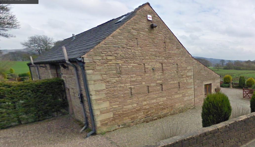
In 2010 I was on a dig in Mellor (near Marple, Derbyshire) looking for the outline of one of the first Cotton Mills, built by Samuel Oldknow in 1790. Finding out more about him, I found that he had started out at Roscoe Lowe Barn some 25 year earlier in Anderton. A building close to where I was living at that time that I drove past regularly and had come across in my reasearch into the 'headless cross' at Grimeford.
For just a few years, there were 150 weavers working in Anderton working for Samual Oldknow of Roscoe Lowe (near Grimford).
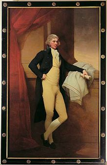
Samual Oldknow was a cotton manufacturer, born 5th October 1756 in Anderton, educated at Rivington.
Samuel Oldknow's family originated in Nottingham, where his grandfather had established a successful drapery business. Oldknow's father, also called Samuel, moved to Anderton in Lancashire to study as a textile manufacturer and became settled there when he married a local girl, Margaret Foster. Sadly, Samuel Snr. died at the early age of 25. During a brief 5 years of marriage he and Margaret had three children, "our" Samuel, born in 1756, followed by Thomas and Elizabeth. The widow Margaret later married for the second time to a farmer, John Clayton. They had three more children, Margery, confusingly another Samuel and John.
For just a few years, there were 150 weavers working in Anderton working for Samual Oldknow of Roscoe Lowe (near Grimford).
Samual Oldknow was a cotton manufacturer, born 5th October 1756 in Anderton, educated at Rivington.
Samuel Oldknow's family originated in Nottingham, where his grandfather had established a successful drapery business. Oldknow's father, also called Samuel, moved to Anderton in Lancashire to study as a textile manufacturer and became settled there when he married a local girl, Margaret Foster. Sadly, Samuel Snr. died at the early age of 25. During a brief 5 years of marriage he and Margaret had three children, "our" Samuel, born in 1756, followed by Thomas and Elizabeth. The widow Margaret later married for the second time to a farmer, John Clayton. They had three more children, Margery, confusingly another Samuel and John.
|
ANDERTON ROSCOE LOWE BROW SD 61 SW 14/8 Roscoe Lowe Farmhouse l7.4.67 GV II
Farmhouse of 2 builds, dated 1683 and 1759, the first containing earlier fabric and now used as store. Squared sandstone with quoins, stone slate roofs. L-shaped plan formed by addition of 1759 at right angles to west gable of earlier building. Two storeys, on sloping site, the later part higher. This is 3 bays, symmetrical except that right end overlaps gable of older part, has gable chimneys, a central doorway with simple moulded architrave, 2 windows at ground floor and 3 above, all relatively large with splayed stone heads, the upper of 3, 2, and 3 lights with chamfered flush mullions, the lower altered as 2-light top-hung casements; the lintel of the 2-light window at 1st floor above the door is inscribed 0 S M 1759 (= Samuel Oldknow). Left gable has a 2-light attic window formerly mullioned, rear has a round-headed 3-stage stairlight with chamfered transoms and central mullion, a small window at ground level below this; right gable, mostly covered by lean-to addition, has an attic window like that in the left gable. The older part is 2 bays, much altered in C18, when it appears to have been raised and cased in stone; the re-entrant or south side has a blocked doorway in the centre, 3-light chamfered flush flush-mullion windows at ground floor and 1st floor right, an altered window at 1st floor left, and close to the junction a little square window at 1st floor lighting a staircase: the north side has a large single-storey gabled porch altered as a washhouse, the gable incorporating a worn datestone lettered in relief (?) F, a doorway and a window in the 1683 both sides of this, another doorway to the left of it, and an altered 3-light window above. The interior of this part has a timber framed partition with remains of a cruck blade at ground floor of the north end; and in the 1st bay, entered from the porch, a structure which may have been an inglenook. History: from this house Samuel Oldknow operated a putting-out system in the local textile industry before moving to Stockport and developing a spinning mill at Mellor. |
