There is plenty of evidence to say that there was a Yarrow Bridge Inn well before 1824 when the inn we see today was built.
How much can we find out about one of Chorley's earliest Inns?
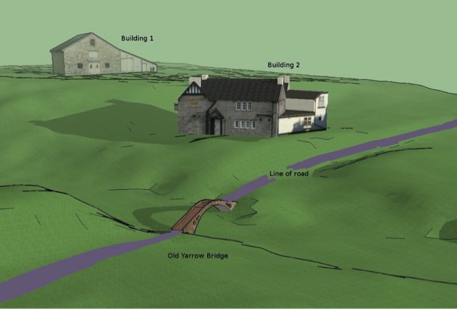
Reconstruction of most likely site of Yarrow Bridge Inn using 1m DTM lidar
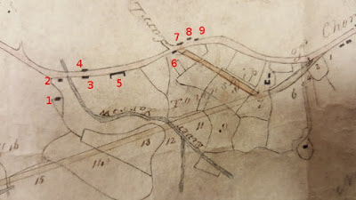
Fig1: 1824 plans for changes to Chorley/Manchester Turnpike (A6)
|
I am investigating the course of the old A6 through Red Bank, Chorley to Duxbury, and came across 2 references to a Yarrow Bridge Inn from before the current Yarrow Bridge Hotel was built in 1824 (See lower down page).
Looking at the 1824 surveyors drawing (Fig1) proposing the current route of the A6, you can see 9 buildings around the original Yarrow Bridge up to Carr Lane. By the time of the 1843 tithe map, buildings 1 to 5 have gone. |
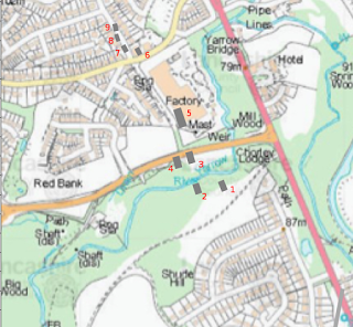
Fig2: Houses from 1824 plan overlaid on modern map
Using lidar data, 3D models and images can be produced of the area.
The route of the old turnpike road can be clearly seen from Fig3 which runs past buildings 5 to 2 and then a cutting is visible heading towards Rawlingson Lane on the other side of the golf course. The roadway/path from the Lodge on the A6 towards can be seen cutting across the old road. 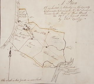
Fig4: 1804 plan of Red Bank showing Building 5 in detail
|
By overlaying Fig1 onto a modern map (I use the excellent Lancashire MARIO mapping system) and using the river Yarrow to best fit the two together, I have marked the approximate position of the 9 buildings in Fig2.
Buildings 1 and 2 are on the Duxbury side of the Yarrow. The old road and footings for the old bridge are still clearly visible today and easy to access from the modern path from the Lodge. Building 2 would be next to the bridge footings. There is also an old horse trough on the west side of the road next to the location of building 2. 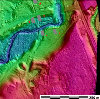
Fig3: 1m DTM Lidar image (red high ground, blue low)
Building 5 is now under the Tenant building, although the position of the building shown on the 1824 map (Fig1) places it next to the still existing road.
Fig4 shows an 1804 plan of Red Bank showing building 5 in more detail. There isn't anything indicating that building 5 is an inn. Building 4 and 3 are probably lost when Miles Standish Way was built a decade ago. However, if you look at the lidar below building 3, you can see the mill race that is clearly visible on the ground, so some portion of it may survive. |
Buildings 6-9 are around the junction of Carr Lane and Melrose Way. There is a stone cottage in the position of building 7 today. Building 6 is probably where the shops are today.
Buildings 2 and 1 are the most likely to survive as they are in woodland. There is a path leading from building 2 to the higher area of building 1. Being close to the river, these are the most likely candidates for the Yarrow Bridge Inn.
In 1808 the Yarrow Bridge Inn is listed as a Post Stage Inn, where horses were changed. The lidar shows a pathway leading up from building 2 up to the higher level to building 1. It is possible that building 1 could be the stables for the Inn. The Yarrow Bridge Inn was most probably on a platform next to the roadway, overlooking the bridge at building 2.
Evidence for the existence of an early Yarrow Bridge Inn/Hotel
1. It is a modern road, the old one to the south of the town being quite different. Of this older road a fragment remains by the 'Image House'; it went by Duxbury Woods and through Red Bank. 'Yarrow Bridge Hotel, a great coaching establishment, mentioned by (Thomas) De Quincey in Confessions of an Opium Eater, stood at the bottom of the houses near the river at Red Bank. The present road was made during the cotton famine succeeding the American [Civil] War.' (British History Online)
A name which was known to travellers through Chorley during the 18th century, when the pub of that name was sited on the old Turnpike Road nearer to Red Bank. Here was a hostelry on the stage coach road, an inn where travellers stopped a while before continuing their journey.
One famous person to stopover was English essayist and critic Thomas De Quincy.
Some of his works ‘Confessions of an Opium Eater’ were written whilst he was at the Yarrow Bridge. (Letter in Chorley Guardian)
2. Aided by about a hundred collier friends, Thomas Standish went to Duxbury Park on June 4, 1813, and dispossessed the resident bailiff. The Preston constables, who were sent for, proving too weak to drive out the invaders, a troop of horse soldiers came from Manchester the next day and took the garrison prisoners.
Thomas Standish and some of his leading friends were indicted for riot, and sentenced to a years imprisonment at Lancaster Castle.
For some time afterwards, however, his sympathisers made demonstrations in the park, and visited the inn at Yarrow Bridge to drink to his better fortune. carousals were known as Duxbury Races and Yarrow Bridge Fair, and some local laureate set the following verse to a popular tune:
" From Wigan the constables brave did repair
To Duxbury Races and Yarrow Bridge Fair;
To keep our true landlord our efforts did fail;
They carried Sir Thomas to Lancaster Jail.
But we'll fetch him back; He nothing shall lack
And in spite of the lawyers and Master Frank Hall,
He shall ride in his carriage to Duxbury Hall,"
Further information at http://www.mylesstandish.info/Parish%20Register%20of%20the%20Church%20of%20St.%20Laurence.htm
