For the last 2 years I have been on the look out for the mysterious John Stone in John Woods, part of Duxbury Woods. I had a rough idea of its location from the milesstandish web site.
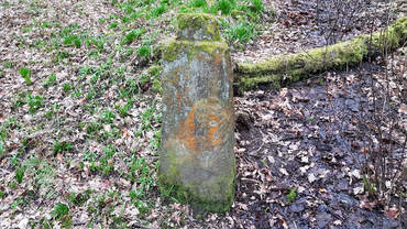
The stone is located half way down the southern wooded slope leading down to the river Yarrow in John Woods, which is part of Duxbury Woods. It takes a bit of clambering around to reach.
The stone is located half way down the southern wooded slope leading down to the river Yarrow in John Woods, which is part of Duxbury Woods. It takes a bit of clambering around to reach.
|
|
The stone is a most unusual shape. 1m tall with a tenon joint on the top, presumably to hold a cross. From a distance it looks like a gate post, but there are no marks on it indicate this and it is location is wrong. It is sited on the edge of a 1m wide ditch, and there is the possibility of a bank running at 90 degrees to the ditch 5m down the slope.
I have created a 3D model (left) from 32 images. I have taken the texture off, so that any markings may be more visible. Click on the play button and have a look yourself. If you think you can see something leave a comment at the bottom of the page. |
I have seen research suggesting that The John Stone is one of 4 stones marking the boundary of land owned by the Knights Hospitalliers of St John, which was the original area of Duxbury, the land being bound by water on 3 sides.
Landscape
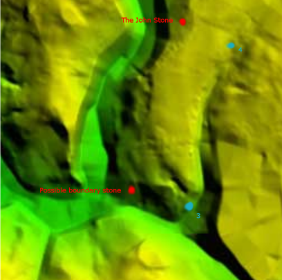
Unfortunately, there is very little landscape data available for all of this area. As it is heavily wooded, there are no aerial photos (except showing tree tops) and there is no lidar coverage. I can only work off low resolution elevation data from Google Earth or try to work with 5m contours.
Landscape
Unfortunately, there is very little landscape data available for all of this area. As it is heavily wooded, there are no aerial photos (except showing tree tops) and there is no lidar coverage. I can only work off low resolution elevation data from Google Earth or try to work with 5m contours.
Possible locations of boundary
Looking at contours and elevation data it is possible to see the promontory area surround on 3 sides by water, river Yarrow, Eller Brook and the small stream running down from Farnworth House joining Eller Brook.
Even on the low resolution image (left) you can see the tongue of land with slopes leading down to water on 3 sides.
The John Stone is top left, and half way down the slope.
There is a marked stone in the old course of Eller Beck (bottom left) which is on today's boundary.
Blue marks 3 and 4 show possible locations of the other 2 corner stones.
Much more research required!
