CHORLEY, DUXBURY, ADLINGTON LOCAL HISTORY
  • Home
  • Local History
    • John Stone - Survey
    • Red Bank
    • Burgh Colliery Railway
    • Chorley Boundary survey 1726
    • Google Earth 3D view of Chorley
    • Tinkler's Barracks
    • Roscoe Lowe - Samuel Oldknow
    • The search for the original Yarrow Bridge Inn
    • Hall o'th Hill
    • Lead Clough Mines - Anglezarke
  • Tenon Top Gateposts
  • Wayside Crosses
    • A-Z Lancashire surviving wayside crosses
    • Bretherton to Croston
    • Longton to Penwortham
    • Wigan to Chorley >
      • Bloody Stone - Newton-le-Willows
    • Hightown to Sefton
    • Mystery of Headless Cross Anderton
  • Anglezarke Survey
    • Site 76-77 - Anglezarke
    • Site 82 - Pikestones
    • Millstone Quarry - Black Coppice
    • Chambered Round Cairn - Site 40
    • Devil's Ditch
    • James Yates Well - Anglezarke
    • Rushy Brow Ruin - Anglezarke
    • Pike Stones Cairn
    • Round Loaf
    • Noon Hill
    • Pike Stones
    • Jepsons Gate Cairn
    • Pikestones Row
  • Roads
    • The John Stone - Duxbury Woods
    • Boundary Stone - Duxbury Coppull
    • The Old Yarrow Bridge
    • Ogilby Road Map
    • 15C route between Chorley and Bolton?
    • 14 Boundary Mounds on Anglezarke
    • Boundary Stones - Turnton Moor
  • Civil War
    • Colonel Thornhaugh
    • The Battle of Wigan Lane
  • News blog posts
  • Contact
  • Knights Hospitallers
  • Dean Ditch Boundary Stones
  • Ribble Ford
  • Lancashire Coast Elevation Map
  • Lancashire Coast Lidar Map
  • New Page
  • New Page


​


Dean Ditch Boundary Stones
​Winter Hill

Picture
Along the northern edge of Winter Hill runs a wall and ditch marking the Parliamentary boundary between Bolton and Blackburn.  It continues along the northern edge of Anglezarke over Spitlers and Redmonds Edge.
The ditch, known as Dean Ditch predates the wall which was built in the 1840's.
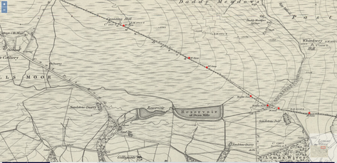
If you look closely at old and modern maps, you will see B.S. annotations marking the spot of boundary markers.

Powered by Create your own unique website with customizable templates.
  • Home
  • Local History
    • John Stone - Survey
    • Red Bank
    • Burgh Colliery Railway
    • Chorley Boundary survey 1726
    • Google Earth 3D view of Chorley
    • Tinkler's Barracks
    • Roscoe Lowe - Samuel Oldknow
    • The search for the original Yarrow Bridge Inn
    • Hall o'th Hill
    • Lead Clough Mines - Anglezarke
  • Tenon Top Gateposts
  • Wayside Crosses
    • A-Z Lancashire surviving wayside crosses
    • Bretherton to Croston
    • Longton to Penwortham
    • Wigan to Chorley >
      • Bloody Stone - Newton-le-Willows
    • Hightown to Sefton
    • Mystery of Headless Cross Anderton
  • Anglezarke Survey
    • Site 76-77 - Anglezarke
    • Site 82 - Pikestones
    • Millstone Quarry - Black Coppice
    • Chambered Round Cairn - Site 40
    • Devil's Ditch
    • James Yates Well - Anglezarke
    • Rushy Brow Ruin - Anglezarke
    • Pike Stones Cairn
    • Round Loaf
    • Noon Hill
    • Pike Stones
    • Jepsons Gate Cairn
    • Pikestones Row
  • Roads
    • The John Stone - Duxbury Woods
    • Boundary Stone - Duxbury Coppull
    • The Old Yarrow Bridge
    • Ogilby Road Map
    • 15C route between Chorley and Bolton?
    • 14 Boundary Mounds on Anglezarke
    • Boundary Stones - Turnton Moor
  • Civil War
    • Colonel Thornhaugh
    • The Battle of Wigan Lane
  • News blog posts
  • Contact
  • Knights Hospitallers
  • Dean Ditch Boundary Stones
  • Ribble Ford
  • Lancashire Coast Elevation Map
  • Lancashire Coast Lidar Map
  • New Page
  • New Page