CHORLEY, DUXBURY, ADLINGTON LOCAL HISTORY
  • Home
  • Local History
    • John Stone - Survey
    • Red Bank
    • Burgh Colliery Railway
    • Chorley Boundary survey 1726
    • Google Earth 3D view of Chorley
    • Tinkler's Barracks
    • Roscoe Lowe - Samuel Oldknow
    • The search for the original Yarrow Bridge Inn
    • Hall o'th Hill
    • Lead Clough Mines - Anglezarke
  • Tenon Top Gateposts
  • Wayside Crosses
    • A-Z Lancashire surviving wayside crosses
    • Bretherton to Croston
    • Longton to Penwortham
    • Wigan to Chorley >
      • Bloody Stone - Newton-le-Willows
    • Hightown to Sefton
    • Mystery of Headless Cross Anderton
  • Anglezarke Survey
    • Site 76-77 - Anglezarke
    • Site 82 - Pikestones
    • Millstone Quarry - Black Coppice
    • Chambered Round Cairn - Site 40
    • Devil's Ditch
    • James Yates Well - Anglezarke
    • Rushy Brow Ruin - Anglezarke
    • Pike Stones Cairn
    • Round Loaf
    • Noon Hill
    • Pike Stones
    • Jepsons Gate Cairn
    • Pikestones Row
  • Roads
    • The John Stone - Duxbury Woods
    • Boundary Stone - Duxbury Coppull
    • The Old Yarrow Bridge
    • Ogilby Road Map
    • 15C route between Chorley and Bolton?
    • 14 Boundary Mounds on Anglezarke
    • Boundary Stones - Turnton Moor
  • Civil War
    • Colonel Thornhaugh
    • The Battle of Wigan Lane
  • News blog posts
  • Contact
  • Knights Hospitallers
  • Dean Ditch Boundary Stones
  • Ribble Ford
  • Lancashire Coast Elevation Map
  • Lancashire Coast Lidar Map
  • New Page
  • New Page

Chambered Cairn -Site 40
Black Coppice - Anglezarke

Between 1983 and 1985 a field survey and 2 excavations were carried out on Anglezarke by the Cumbria and Lancashire Archaeological Unit. Noted in the survey as Site 40 was reference to a  chambered round cairn on Sronstrey Bank at Black Coppice (overlooking White Coppice). I have looked twice in the past 10 years, but using the map in the survey and a gps app on my phone, finally tracked it down to start recording it.
The report states:
The chambered round cairn (site 40) is of an unusual type. It is a large, slightly pear-shaped, prominent cairn and has a chamber formed by a large unworked slab, used as a capstone. This stone slopes down to the ground at the back, but is supported at the front by an upright portal on one side, and the body of the cairn on the other. Although the chamber is incorporated with a cairn and is not free standing, there are similarities with some of the megalithic tombs of north Wales.
​

Chambered round cairn Site 40 Anglezarke by csdrabble on Sketchfab

Have a look at the cairn yourself. Click the Play button and move the model around to view it.
Disappointing first results for the 3D model. The software seems to struggle to recreate the entire covering slab.
I carried out a drone survey to determine the overall shape of the cairn which you can view in the 3D model below.

Chambered Cairn - Black Coppice Anglezarke by csdrabble on Sketchfab

Picture
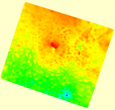
The first elevation models produced did not show the shape of the cairn as the whole side is on a slope.  By placing the model flat, I was able to produce the following hill shade image which shows the cairn to be more circular that it appears on the ground. 


    Have you any comments on this chambered cairn?

Submit
Powered by Create your own unique website with customizable templates.
  • Home
  • Local History
    • John Stone - Survey
    • Red Bank
    • Burgh Colliery Railway
    • Chorley Boundary survey 1726
    • Google Earth 3D view of Chorley
    • Tinkler's Barracks
    • Roscoe Lowe - Samuel Oldknow
    • The search for the original Yarrow Bridge Inn
    • Hall o'th Hill
    • Lead Clough Mines - Anglezarke
  • Tenon Top Gateposts
  • Wayside Crosses
    • A-Z Lancashire surviving wayside crosses
    • Bretherton to Croston
    • Longton to Penwortham
    • Wigan to Chorley >
      • Bloody Stone - Newton-le-Willows
    • Hightown to Sefton
    • Mystery of Headless Cross Anderton
  • Anglezarke Survey
    • Site 76-77 - Anglezarke
    • Site 82 - Pikestones
    • Millstone Quarry - Black Coppice
    • Chambered Round Cairn - Site 40
    • Devil's Ditch
    • James Yates Well - Anglezarke
    • Rushy Brow Ruin - Anglezarke
    • Pike Stones Cairn
    • Round Loaf
    • Noon Hill
    • Pike Stones
    • Jepsons Gate Cairn
    • Pikestones Row
  • Roads
    • The John Stone - Duxbury Woods
    • Boundary Stone - Duxbury Coppull
    • The Old Yarrow Bridge
    • Ogilby Road Map
    • 15C route between Chorley and Bolton?
    • 14 Boundary Mounds on Anglezarke
    • Boundary Stones - Turnton Moor
  • Civil War
    • Colonel Thornhaugh
    • The Battle of Wigan Lane
  • News blog posts
  • Contact
  • Knights Hospitallers
  • Dean Ditch Boundary Stones
  • Ribble Ford
  • Lancashire Coast Elevation Map
  • Lancashire Coast Lidar Map
  • New Page
  • New Page