Chorley Boundary survey 1726
In 1726 a jury made up of Chorley citizens walked and recorded the Chorley Boundary.
There is an enormous amount of detail in their report and it is possible using the modern boundary and historic maps to place some of the names mentioned.
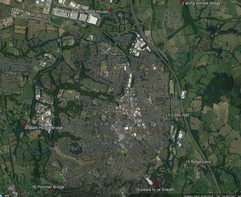
This is an ongoing investigation and this Google Earth image will be updated and new results are found:
There is an enormous amount of detail in their report and it is possible using the modern boundary and historic maps to place some of the names mentioned.
This is an ongoing investigation and this Google Earth image will be updated and new results are found:
Survey Note |
Findings |
1: Beginning at ye Lane end by Abbot House |
The survey team met at the top of Hartwood Green and probably stared from the boundary stone on the A6 next to the Sea View |
2: and so along Whittle hedge |
The boundary runs East along a hedge line for 1 mile from the A6, over the M61, the canal and Blackburn road to North/South hedge running along Tan House Brook. |
3: so up Hunter Slade to Heapey hedge and ditch |
(Slade = little valley) Tan House Brook runs south down a valley. |
4: and so on to Blackbrook gate near Heapey |
|
5: and so thorow greehalgh croft to a style in Lawson's ground by Healey |
|
6: and so along by ye hedge and rivulet to Gibb Close |
|
7: and so on ye back side of Gibb Close, dividing Healy from Chorley |
|
8: From thence by ye ffleam ditch to ye Paddock gate |
|
9: and so on to Baginley in James Parker's Lane Throu' a Croft Leading to ye Hardfield - betwixt Healy and Chorley |
|
10: and so from Hardfield style neer ye gate at Healey Miln |
|
11: and so to an oak at ye Carthouse and at Cross Hall |
Cross Hall used to be on Cross Hall Lane but is not on the boundary. Maybe the estate runs to the boundary??? |
12: So thoro ye Courts into ye Brew house |
Value |
13: and so thoro ye Brew house and part of ye orchard to ye bottom of ye barley croft. |
|
14: Then to ye Butcher-ridding |
Value |
15: and so to ye steel in yet Ridge Land |
this could be 'The Ridges' on Weavers Brow. There is a boundary stone here. |
16: and so thoro ye Little Croft |
|
17: then at the bottom of Worsley Close |
Value |
18: to a Weare Betwixt Twitchells and Long Shoot |
Value |
19: and so alont ye hedge from ye weare to ye Sneath |
Value |
20: and ye brook that divides Chorley and Healey to Sr Thomas Stansish's land in Duxbury |
Value |
21: to a fforth that formerly went out of James Whittles meadow |
|
22: ffrom a witch Hassle to a Swee William where ye water wen formerly down before it was turned and so to Sr Thomas Standishs' Coe |
|
23: and so to a gravel bed in Yarrow |
|
24: and round the stream Ditch to John Holdens Cellar |
|
25: a snd so up to a Holling Bush where formally a gate stood wch parted Chorley and Duxbury. |
|
26: But before we come to ye coe there is a croft belonginge to John Aspden's tenemt which was taken out of ye Great Bottoms wch is called Paddock that belongs to Duxbury |
Great Bottoms appears on a 1757 estate map of Duxbury where Black Brook joins the Yarrow. |
27: and so thoro the Jewell's Croft to Sr Thomas Standish Horse-Hey |
|
28: ans so taking Richard Wasley's intack to ye ffearnely |
|
29: and so to Thomas Wilcocks Tenement |
|
30: ansd so to a close of ground formerly Edward Waring's called ye acre |
|
31: and so to a Close called Comaker and being on Rigby's land |
|
32: and soe to a Rivulett on ye North side of Mr Rigby's Ware-house |
|
33: and there to a Rivulett running thoro Long Hey-wood to a Coe in ye bottom fo ye Long Hey-wood |
|
34: takeing in a little houme lying to Jarmand houme |
|
35: and then Yarrow part Chorley and Coppull to Crosseness Brook |
|
36: and then Yarroe parts Chorley and Charnock Ricd to ye Plimmer Bridge (excepting three crofts, Paddocks, or parcellsof Land belongeing to ye Lands's fo Saml Crook Esqr Decd) |
Plimmer bridge on the Yarrow is now called Plymouth Bridge at Dob Brow. |
37: and so to ye Bark-House Bridge (excepting one Hillock) formerly James Charnock's |
Bark-House bridge still exists over the Yarrow between German Lane and Common Bank Lane. |
38: and so down a hedge bewixt Lee Houme and Sis houme abt 2 roods |
|
39: Soe to a corner of Smiths Ramskar's |
|
40: and so down ye sd Ramskar's for ye space of 24 yds over agt Lower Miln Holm belonging to Kingsley house ground |
|
41: and so down to ye Bottom of a Little Croft of Tho Waring's |
|
42: and then up a Rivulett to ye bottom of Common Bank |
|
43: and then up a Rivulett parting Mr Gellibrand's Land and Mr Robinsons Land laeing in Euxton |
|
44: and so after ye Bottom of Judds Lands all alng Astley Demesne to Euxton Brook |
|
45: and soe after to Abbot's Tenemt to Astley Demesne |
|
46: and so after ye Bottom of Judd Lands all along Astley Demesne to Euxton Brook |
Euxton Brook runs from the B5252 the the railway track |
47: and so after to Abbot's Neemet adjoyneinge to Wm Ffool's Tenemt lyeinge in Whittle |
|
48: and so up to Lane End by Abbot's Tenemt dividing Chorley from Whittle |
|
Coe: a small hut or shack over a mine
Slade: little valley
Croft: a small enclosed field usually adjoining a house; a small farm worked by a tenant
Demesne: manorial land actually possessed by the lord and not held by tenants
Rivulet: a small stream
Sneath: a cut off piece of land (Norse)???
Slade: little valley
Croft: a small enclosed field usually adjoining a house; a small farm worked by a tenant
Demesne: manorial land actually possessed by the lord and not held by tenants
Rivulet: a small stream
Sneath: a cut off piece of land (Norse)???
