CHORLEY, DUXBURY, ADLINGTON LOCAL HISTORY
  • Home
  • Local History
    • John Stone - Survey
    • Red Bank
    • Burgh Colliery Railway
    • Chorley Boundary survey 1726
    • Google Earth 3D view of Chorley
    • Tinkler's Barracks
    • Roscoe Lowe - Samuel Oldknow
    • The search for the original Yarrow Bridge Inn
    • Hall o'th Hill
    • Lead Clough Mines - Anglezarke
  • Tenon Top Gateposts
  • Wayside Crosses
    • A-Z Lancashire surviving wayside crosses
    • Bretherton to Croston
    • Longton to Penwortham
    • Wigan to Chorley >
      • Bloody Stone - Newton-le-Willows
    • Hightown to Sefton
    • Mystery of Headless Cross Anderton
  • Anglezarke Survey
    • Site 76-77 - Anglezarke
    • Site 82 - Pikestones
    • Millstone Quarry - Black Coppice
    • Chambered Round Cairn - Site 40
    • Devil's Ditch
    • James Yates Well - Anglezarke
    • Rushy Brow Ruin - Anglezarke
    • Pike Stones Cairn
    • Round Loaf
    • Noon Hill
    • Pike Stones
    • Jepsons Gate Cairn
    • Pikestones Row
  • Roads
    • The John Stone - Duxbury Woods
    • Boundary Stone - Duxbury Coppull
    • The Old Yarrow Bridge
    • Ogilby Road Map
    • 15C route between Chorley and Bolton?
    • 14 Boundary Mounds on Anglezarke
    • Boundary Stones - Turnton Moor
  • Civil War
    • Colonel Thornhaugh
    • The Battle of Wigan Lane
  • News blog posts
  • Contact
  • Knights Hospitallers
  • Dean Ditch Boundary Stones
  • Ribble Ford
  • Lancashire Coast Elevation Map
  • Lancashire Coast Lidar Map
  • New Page
  • New Page

Boundary stone found in Coppull Hall Woods

Picture
Picture
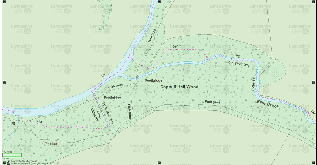
If you look at the parish/parliamentary boundary between Duxbury/Coppull/Chorley at a point where they meet in Coppull Hall Woods (the old gps on the phone trick) there is something interesting going on.
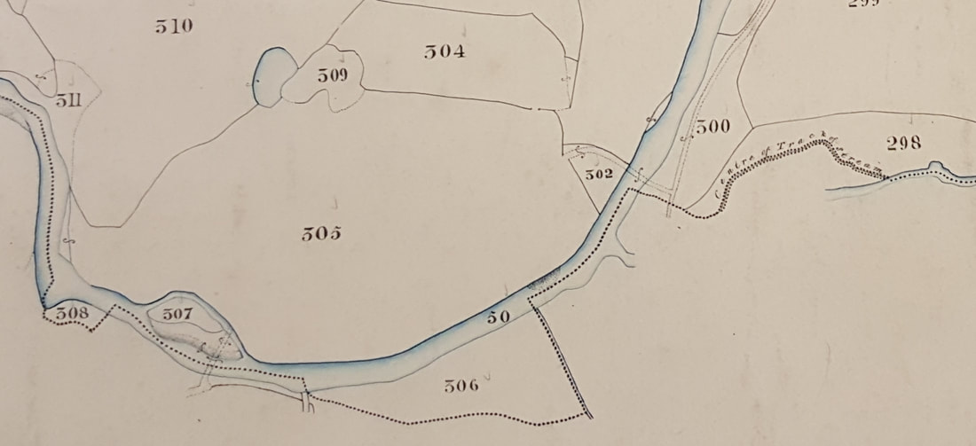
The boundaries are down the centre of the River Yarrow until it get to the point where the 3 meet, where it wanders some 20m into the woods then back to the river. At the the furthest point there was a 3m pit and next to it this stone (1m x 1.5m). Spotted what looked like a groove, and when cleaned it back there is a 1m cut groove, yes you guessed it, running along the line of the boundary.

A quick 3D model was produced which you can view below. Have a look round the stone and see if there are any other marks.​
The 1830's Tithe map shows the area the stone is in as the 'Course of Track of Stream' so presumable, the boundary was set when before Eller Brook changed course and the stone placed to mark the old course.

Duxbury Coppull Boundary Stone by csdrabble on Sketchfab

The investigation into this boundary stone is part of the larger '3rd Yarrow Bridge' survey which will investigate the whole area round here.
Powered by Create your own unique website with customizable templates.
  • Home
  • Local History
    • John Stone - Survey
    • Red Bank
    • Burgh Colliery Railway
    • Chorley Boundary survey 1726
    • Google Earth 3D view of Chorley
    • Tinkler's Barracks
    • Roscoe Lowe - Samuel Oldknow
    • The search for the original Yarrow Bridge Inn
    • Hall o'th Hill
    • Lead Clough Mines - Anglezarke
  • Tenon Top Gateposts
  • Wayside Crosses
    • A-Z Lancashire surviving wayside crosses
    • Bretherton to Croston
    • Longton to Penwortham
    • Wigan to Chorley >
      • Bloody Stone - Newton-le-Willows
    • Hightown to Sefton
    • Mystery of Headless Cross Anderton
  • Anglezarke Survey
    • Site 76-77 - Anglezarke
    • Site 82 - Pikestones
    • Millstone Quarry - Black Coppice
    • Chambered Round Cairn - Site 40
    • Devil's Ditch
    • James Yates Well - Anglezarke
    • Rushy Brow Ruin - Anglezarke
    • Pike Stones Cairn
    • Round Loaf
    • Noon Hill
    • Pike Stones
    • Jepsons Gate Cairn
    • Pikestones Row
  • Roads
    • The John Stone - Duxbury Woods
    • Boundary Stone - Duxbury Coppull
    • The Old Yarrow Bridge
    • Ogilby Road Map
    • 15C route between Chorley and Bolton?
    • 14 Boundary Mounds on Anglezarke
    • Boundary Stones - Turnton Moor
  • Civil War
    • Colonel Thornhaugh
    • The Battle of Wigan Lane
  • News blog posts
  • Contact
  • Knights Hospitallers
  • Dean Ditch Boundary Stones
  • Ribble Ford
  • Lancashire Coast Elevation Map
  • Lancashire Coast Lidar Map
  • New Page
  • New Page